Delaware Avenue: Interpretive Trail
You will find interpretative posts along both sides of the unimproved Delaware Avenue road and near the edge of its surrounding forests.
Start at the northern most post labeled with the letter “A” and scan the targets on the posts to access web informational pages. They will help you learn some details about the forests here and how managing fire plays an important and positive role in the ecosystems’ health, safety, resiliency, and biodiversity. Proceed south and you will work from one side to the other in a loop until you wind up at the final post lettered “I” back near the beginning. The entire loop is under 0.4 miles.
We hope this trail, its web pages and additional links will help you understand some aspects of our Pinelands forest fire ecology, define some basic fire terms, and showcase some of Stockton’s faculty and student long-term research. We also hope the trail and web site will give you insight into how fire can used as part of a comprehensive ecological forest management plan–as we have here at Stockton–to make our forests safer, more diverse, and resilient.
DELAWARE AVENUE FOREST INTERPRETATIVE TRAIL STOP A
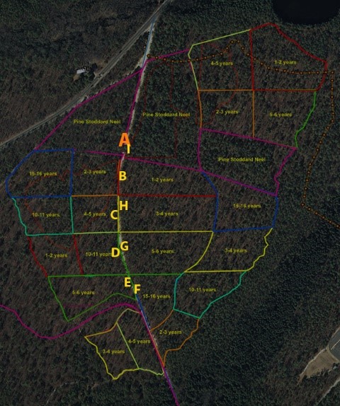
The last prescribed fire on Delaware avenue forests (before the SFMP) was in 2005 (south side) and 2006 (north side).
DELAWARE AVENUE FOREST INTERPRETATIVE TRAIL STOP B
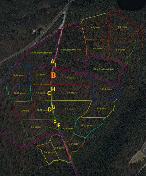
In front of you (facing Post B) is one of the three replicates of the 2-3 year fire interval treatments. Behind you across Delaware Avenue is one of the replicates of the 1-2 two year (or shortest) fire interval treatment in this experiment.
When the experiment started in 2015, the entire 60 acre area was burned to set all treatments at the same starting point. In 2016 and again in 2017 the 1-2 year areas have been and will be burned (we hope to do so every year into the foreseeable future). However, the 2-3 year areas were burned in 2017 and will not be burned again for two years. Since we cannot guarantee a burn every year (as you will learn later), we have an “extra year” added in each treatment name (“1-2”, “2-3”, “3-4”, etc.).
Here is a movie of the 1-2 year treatment prescribed burn done of February 28th 2016:
So can you see anything happening in the 2-3 or especially the 1-2 two year treatments yet?
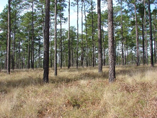
We believe the short time fire intervals will favor species like pine and grasses and thick barked or older specimens who are best adapted to fire, while less adapted species or individuals will die. In the southern United States, short time fire return intervals can produce pine savannahs with understories of grass that host their own unique species.
In the stops ahead, we will explain more of how prescribed burns are done, some fire "basics", and the research we are doing.
DELAWARE AVENUE FOREST INTERPRETATIVE TRAIL STOP C
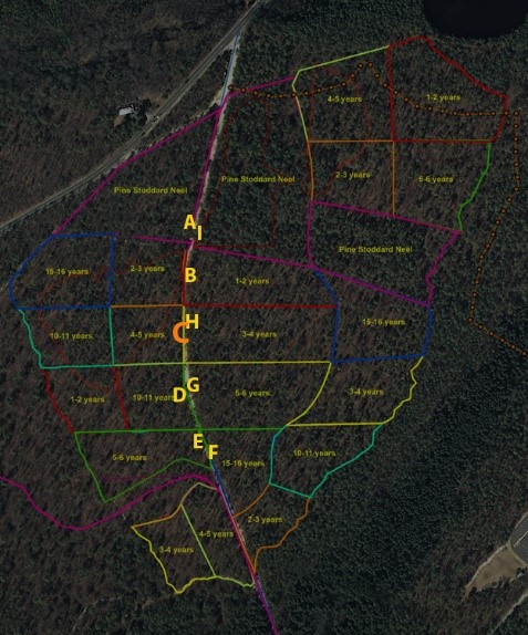
As you face post C you will see one of three replicates of the 4-5 year fire interval treatments. Like all treatments it was burned at the beginning of this experiment in 2015, but is not scheduled to be burned again for at least 4 years (in the year 2019).
Some fire basics:
Fire is as important to some forest ecosystems as rain is to some Amazonian forests. Unfortunately in America, a catastrophic fire in 1910 called the Big Burn and subsequent public reaction caused America to characterize all fires as bad and embark on suppressing all fires. Smokey the Bear and the United States Forest Service’s initial ad campaigns for most of the 20th century made the public believe ALL fires had to be suppressed or stopped. It is certainly true that catastrophic canopy fires can result in death and property loss, but not all fires are bad. Some forested ecosystems have adapted to having fire as an important component in their development through evolution and adaptation over a millennia.
There are three basic types of forest fires. The worst and most catastrophic are crown fires where the fire travels throughout the entire forest and especially in the crowns of trees. They release tremendous amounts of energy, and cause great damage. Catastrophic crown fires can also produce unique conditions and subsequent different ecosystem trajectories.
The other types of fire are:
Surface fires - these fires stay on the surface and do not travel up to the tree crowns
and ground fires - these fires actually burn the ground itself. Peat if dried can burn in cedar swamps like the Great Dismal Swamp fires, which could not be extinguished for months and eliminated, for hundreds of years, the possibility of any more cedar stands regnerating and growing in that area! Substances like surface/subsurface coal veins (as witnessed in Centralia, Pennsylvania) can burn for years with no possibility of being extinguished.
Partly because of government policies suppressing any fires and not using prescribed burns (surface fires intentionally set and controlled by humans) we have allowed fuel buildups, and thus changes in forest structure, to occur over many decades. Those changes in the forest by fire suppression policies, combined with climate shifts, have caused many Western (and also some Eastern forests) to catastrophically burn at rates and acreage never seen before. These catastrophic forest fires cost the taxpayers billions of dollars to control and billions in damages, loss of life and precious ecological habitats. But there are ways through ecological forest management we can safely use fire and other techniques to create conditions to lessen catastrophic fire threats and maintain ecosystem integrity and biodiversity.
Here in the Pinelands in New Jersey, the pygmy pine plains are areas where catastrophic and historically frequent fires have created some forests that are adapted to complete crown burning and recovering through sprouts from root systems which survive the flames above ground, and through cones which remain closed but open after fires to release seeds (serotinous cones). There are also many Pineland forests (with pines usually possessing mostly non-serotinous cones) that are more adapted to periodic surface rather than crown fires. We also have some Pineland forest types like Atlantic white-cedar that are usually found in more wet areas where fire is not usually a factor in their survival, growth, and adaptation.
DELAWARE AVENUE FOREST INTERPRETATIVE TRAIL STOP D
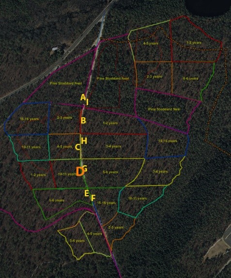
As you face post D you will see one of the replicates of the longer fire intervals: 10-11 years. This, along with all acreage, was burned in 2015, but will not be burned again till 2025. We expect – as has happened in most fire suppressed forests in New Jersey and across the United States – that longer interval times between fires will produce more plant growth and thus more fuels. The danger from long periods of no fire is that they create conditions which produce continuous bands of ladder fuels that expand from the forest surface to the live canopy. If a surface fire starts in a fuel-rich forest it can burn, unimpeded, up these 'ladder' fuels and thus into the canopy where it becomes a dangerous canopy fire – the kind of forest fires that you have seem devastated the West and even places in the East. Currently, the fuel buildups in many New Jersey forests are dangerous, and if we experience sustained drought conditions like the West has seen, we could have more devastating fires in New Jersey. The use of prescribed burns and forest thinning can be effective ways to combat the threats of forest fuel buildups and reduce catastrophic forest fire damage to life and property.
DELAWARE AVENUE FOREST INTERPRETATIVE TRAIL STOP E
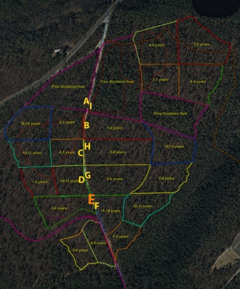
As you face post E you will see one of the three 5-6 year fire interval replicate treatments. This area along with all acreage was burned in 2015, but will not be burned again till 2020.
Some more fire basics
The formula for any fire is simple:
FUEL + IGNITION (HEAT)+ OXYGEN=FIRE
If you do not have all three ingredients, you cannot start a fire. This formula also gives us insight into how to control and or stop fires. Stockton University, as well as all NJ citizens, have the benefit of the NJ Forest Fire Service (NJDEP) and their expertise to fight catastrophic forest fires when they occur, but also reduce threats from crown fires and produce ecological benefits by conducting prescribed burns.
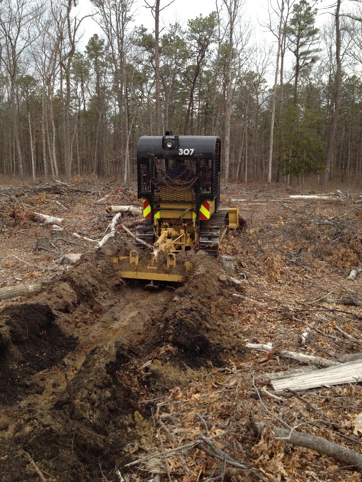
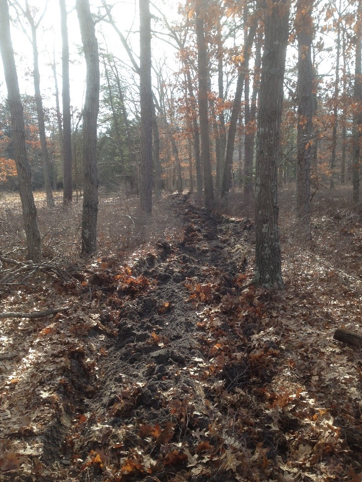
There are a number of ways to conduct a prescribed burn, but before you burn you must create or use fire breaks to contain the fire. The way most commonly done is to create plow lines. The plow line will produce a band of soil (hence no fuel) so when the surface fires hits the plow line the fire stops for lack of fuel. Below is a picture of a plow line we initially put down for a burn at Stockton:
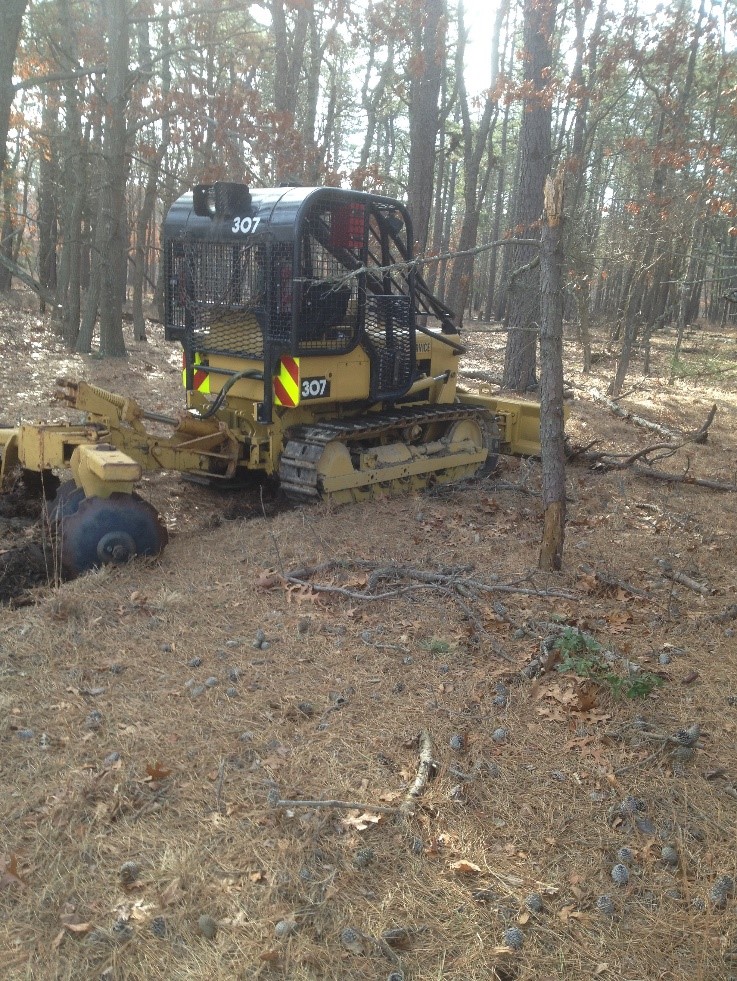
These plow lines can act on land with sloping topography to channel rain and affect forest hydrology. N.J.D.E.P. Forest Fire Service Officials were asked to disk rather than plow to minimize channeling water. The fire breaks as seen in the photos below demonstrate this being done at Stockton. The disked fire breaks are a bit wider than plowed lines, but do not channel rain water and allow better rain infiltration, thus minimizing reallocation of forest water.
DELAWARE AVENUE FOREST INTERPRETATIVE TRAIL STOP F
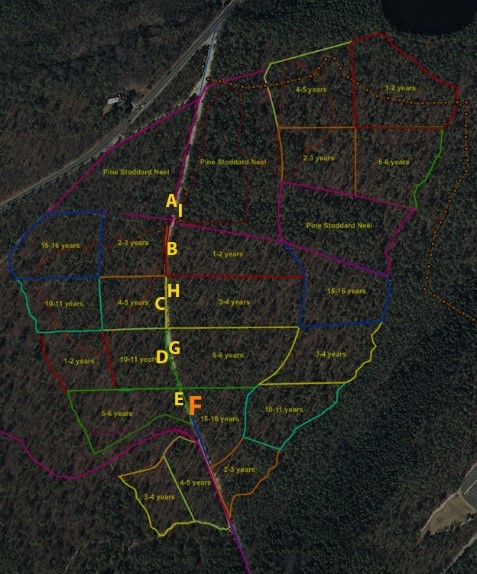
As you face post F you will see the longest fire interval: 15-16 years. This replicate along with all acreage was burned in 2015 but will not be burned again till 2030. When a forest that has evolved for millennia under periodic fires, and has no fire for decades or more, the lack of fire can alter its structure and trajectory. Specifically, we expect more ladder fuels (and more fuels in general) during these longer fire intervals which will result in a much higher probability of catastrophic canopy fires.
Prescribed burns are one way to reduce fuel loads provided the situation is not too dangerous to set any fire (in which case thinnings or mechanical fuel reduction may be needed before reintroducing fire in the form of prescribed burns.)
Some more fire basics:
Once fire breaks are in place you can conduct a prescribed burn, but there are rules in each State on the parameters to do this. In New Jersey prescribed burns are conducted from October to mid- March (usually referred to as ”winter burns”) when forest fire officials can minimize smoke, and weather conditions allow for safer burns to occur (wind speeds must be minimal, temperature, humidity, air mass stability and fuel moistures must also be within specific narrow ranges, etc.)
On the Delaware Avenue forests, NJDEP Forest Fire Service officials have been conducting a combination of head fires (fire is set with wind) :
and back fires (fire set against the wind) – this will affect the rate of the burn, temperature of the burn, among other parameters. NJDEP Forest Fire personnel have also done 'strip' fires which the time lapse video below shows occurring in 2015 on the 1-2 year (block I replicate):
DELAWARE AVENUE FOREST INTERPRETATIVE TRAIL STOP G
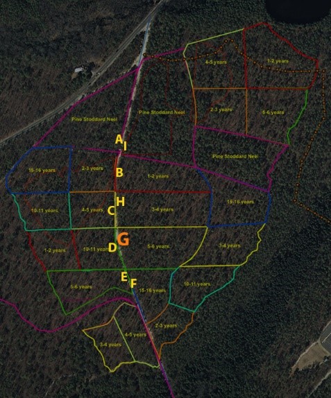
As you face post G you will see the 5-6 year fire intervals. This replicate along with all acreage was burned in 2015 but will not be burned until 2020. To be able to quantify what the fires are doing and have baseline information and data to analyze; the faculty and students of the Environmental Studies Program have been using state of the art equipment and delineating permanent plots that study and will remeasure over the decades ahead various forest ecosystem parameters.
DELAWARE AVENUE FOREST INTERPRETATIVE TRAIL STOP H
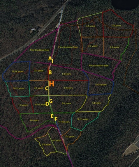
As you face post H you will see one of three replicates of the 3-4 year fire interval treatment. On a sample of these fire interval replicates we have employed cutting edge technology called LiDAR (Light Detection and Ranging). We have a LiDAR unit from Leica called the P-20 which you can see students using in the video below. It uses a laser scanning up to one million points per second as the unit revolves 360 degrees in the X-Y axis and 270 degrees along Z axis. From the laser returns it produces three-dimensional pictures of the forest that can be modeled and measured. After the initial laser scan, the LiDAR unit then can take a mosaic of RGB photos that can be stitched together and ‘draped’ over the three-dimensional laser model for photorealistic three dimensional representations of the forest. Students in Mr. Mike Cicali’s LiDAR class spent a lab using the Leica P-20 unit and stitching multiple stations along Delaware Avenue to create this three dimensional view of part of Delaware Ave you are on.
DELAWARE AVENUE FOREST INTERPRETATIVE TRAIL STOP I
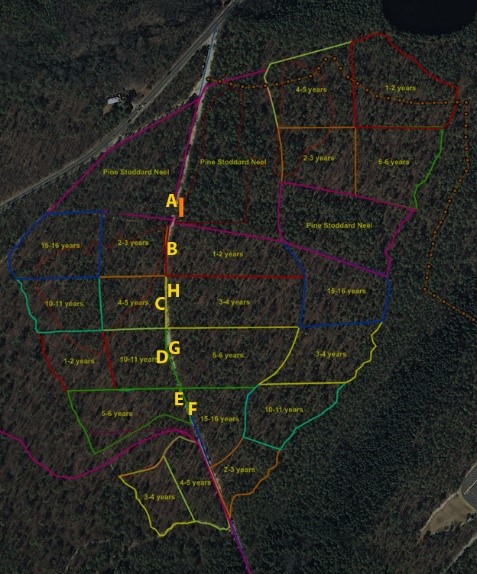
As you face post I you will look into an area that is part of another fire-related project: our use of the Stoddard-Neel ecological forest management approach. Many times in the past people have cut trees and forests with only their own needs in mind and did not consider or place ecological values of the forest over economic gain. In the Southern United States where the timber industry is strong this can be particularly true. Starting in the 1950s Leon Neel and Herb Stoddard teamed up to find a better way to manage Longleaf pine ecosystems (some of the most diverse forest ecosystems) that were dwindling under industrial forestry pressures in the South for decades. Their approach uses primarily fire, individual tree selection, and time (it takes a long time to grow a big tree!) to eventually shape and create old growth pine ecosystems that have a multi- or all- aged structure- probably more natural than the even-aged forests that can a result of mass logging practices when ecology took a back seat to profit.
Here in front of you is a stand that has had some limited low thinning done in late spring 2017, and fire which has been part of this stand at least once in 2015 will be back on a fairly regular schedule. A few of the larger trees in front of you are about 90 years old, and there are other trees in this Delaware Avenue forest, Stockton Environmental Studies students have measured to be over 130 years old.
Today the work of Stoddard-Neel is being advanced and further studied in many places including the Joseph W. Jones Ecological Research Center in Georgia.
For more details on this approach read the booklet at this link.
